 |
||
| ||
|
Data U.S. Time Zone Boundaries DESCRIPTION 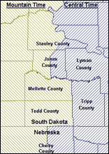 Time Zones, and their boundary lines, are established by Federal statute. While most of the time zone division lines fall on county boundaries, a number do not... the exceptions fall along township and section boundaries as defined by the Public Land Survey System. It is also true that the beginning and ending dates for the observance of Daylight Savings Time are standardly established by statute... but certain states and certain counties decline to observe Daylight Savings Time. This mapped table records each county of the U.S. and, where a county is split by a time zone boundary, each part of that county separately. For each of these, the table records the Time Zone and whether Daylight Savings Time is observed.
USAGE Time Zone and Daylight Savings information is useful to those who must contact people or businesses in diverse locations and who need to know what the time is in the location to be reached. SPECIFICATIONS The US Time Zones database consists of a single mapped table, using NAD83 latitude/longitude coordinates. FORMATS AVAILABLE MapInfo ArcView/GIS and ARC/INFO DATA DISTRIBUTED ON CD-ROM DATA FIELDS FIPS: FIPS Code of the county (split counties appear twice) State: State abbreviation County: Name of the county (split counties appear twice) TimeZone: Time Zone, expressed as hours less than Greenwich Mean Time DST: Indication (1 or 0) of whether the entity observes Daylight Savings Time PRICE: $995 / US (call for multi-user licensing) DOWNLOAD a free sample reflecting part of the Central/Mountain Time Zone division |
:: World Time Zones and Daylight Saving Time :: U.S. Terrain Areas :: U.S. Time Zone Boundaries :: WorldInfo | ||||||||||