 |
||
| ||
|
Data U.S. Terrain Areas DESCRIPTION U.S.Terrain Areas provide terrain information derived from the State Soil Geographic (STATSGO) database that was developed by the U.S. Agriculture's Natural Resources Conservation Service (NRCS). The STATSGO database was designed for resource planning at a regional level. Examples of terrain attributes are slope, bedrock depth, water table depth, rock hardness, and surface texture. U.S. Terrain Areas cover the continental United States, Alaska, Hawaii, and Puerto Rico. The datum of the maps is NAD 27, and the scale is 1:250,00, except for Alaska, which is 1:1,000,000. 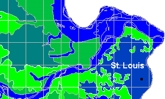 U.S. Terrain Areas is actually two products in one. It includes a set of digital maps for display purposes and a companion set better suited for geographic processing. the display version contains the original, unaltered geographic terrain areas and is perfect for online viewing and map-making. The above image illustrates the display version of U.S. Terrain Areas.  The companion set contains the same terrain information in digital maps that are optimized for geographic processing. The geographic areas are gridded, resulting in areas that are no larger than one-tenth of a degree of longitude by one-tenth a degree of latitude. The gridded format of U.S. Terrain Areas helps cut down the processing time of intensive spatial joins with the product. USAGE U.S. Terrain Areas is an excellent source of terrain information for resource planning, management, and monitoring at a regional level; multi-county, state, multi-state, etc. SPECIFICATIONS Each set (display and gridded) of the U.S. Terrain Areas database consists of one table for each of the 50 states, plus Puerto Rico. FORMAT AVAILABLE MapInfoArcView GIS and ARC/INFO DISTRIBUTED ON CD-ROMDATA FIELDS MUID: STATSGO terrain area identifier SlopeL: Minimum value for the range of slopes SlopeH: Maximum value for the range of slopes SurfTex: Predominant surface texture AnFlood: Annual flooding frequency AnFloDur: Annual flooding duration AnFloEnd: Month during which flooding ends AnFloBeg: Month during which flooding begins WTDepL: Minimum value for the range of depth to water table WTDeptH: Maximum value for the range of depth to water table RockDepL: Minimum value for the range of depth to bedrock RockDep: Maximum value for the range of depth to bedrock RockHard: Degree of hardness of bedrock HydGrp: Hydrologic group for the soil Drainage: Drainage class of the soil hydric: Hydric soil identifier CorCon: Concrete corrosion susceptibility rating CINIrr: Non-irrigated agricultural usage rating SCINIrr: Non-irrigated agricultural usage subclass PrimFml: Prime farmland classification PRICE:$6,000 / US (call for multi-user licensing) DOWNLOAD a free sample of U.S. Terrain Areas. |
:: World Time Zones and Daylight Saving Time :: U.S. Terrain Areas :: U.S. Time Zone Boundaries :: WorldInfo | ||||||||||